Soil as an archaeological archive: A contribution to World Soil Day on December 5th
Isabel A. Hohle and Melani Podgorelec (translation: Arie Kai-Browne)
„The International Soil Science Union (IUSS) has designated December 5th as World Soil Day at its 17th World Congress, held in Bangkok in August 2002. It is intended to be an annual symbol of the importance of soil as a natural resource„. (https://www.bvboden.de/aktuelles/weltbodentag)
Soil is a natural resource, the importance of which is fortunately increasingly coming into focus of various sciences. Due to its archive function, soil is a carrier of information about past processes and environmental conditions, but also about human activities and thus a resource for knowledge. For this reason, archaeologists are increasingly concerned with making soil usable as a source and archive for their research, documenting it and preserving it as cultural heritage. Research into climate change and the human factor are of particular interest here, as well as the way in which humans deal with the resulting challenges is currently being investigated and discussed at the German Archaeological Institute (DAI) as part of the Ground Check initiative (https://www.dainst.org/-/ground-check-cultural-heritage-and-climate-change?redirect=%2Fdai%2Fmeldungen and https://www.youtube.com/playlist?list=PLq4Pz4R7ts0VNR37nnAfTTiZqVmQ8mQiO ). On the subject of the Anthropocene, the Romano-Germanic Commission (RGK) 2019, for example, held a panel discussion at the book fair in Frankfurt (Mensch – Ding – Welt: Ein langer Weg zum Anthropozän).
What used to be dug up and shovelled away during excavations is now being sampled in various ways and in some cases is even being archived. For example, archaeological state offices in Germany list the retrieval of soil samples for various investigations in their excavation guidelines. The RGK also systematically archives soil samples from various excavations and drilling campaigns. Buried monuments which are not endangered are left protected by the soil, where they are best preserved. Drilling, as a minimally invasive method, offers the opportunity of obtaining a great deal of information about archaeological sites when excavations are not possible or not necessary.
“Die haben ordentlich Dreck am Stecken!” An example of research on and with soil samples at the RGK
This old German phrase can roughly be translated as “someone having dirt stuck to them” and means that someone is guilty of questionable or illegal activities. The phrase originates from the times when paths were not yet paved and people had dirty shoes all the time. So before entering a building, you had to clean your shoes. This was done with a so-called “Stecken”, which is a stick (for more details, please check out ARD Audiothek: https://www.ardaudiothek.de/1000-antworten/woher-kommt-die-redewendung-dreck-am-stecken-haben/68812876). In a figurative sense, it also means that someone has something to hide or has taken guilt upon himself because dirt stood and stands in contrast to purity and innocence.
Of course, archaeologists do not only stick to the usual hygiene guidelines in these current times. And since we too are mainly working in the home office instead of carrying out field research, our shoes stay clean. Which does not mean that we do not nevertheless deal with „dirt“.
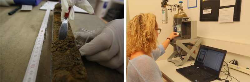
If paths were not paved, how do archaeologists manage to prove that they existed at all? There are several approaches and one way shall be discussed in detail. Sediments from archaeological remains contain a wealth of (initially invisible) information. Minimally and non-invasive methods are becoming increasingly important in field research carried out by the RGK and its Unit for Survey and Excavation Methodology (RefPGM) (see also blog entry Das Referat für Prospektions- und Grabungsmethodik der RGK stellt sich vor and radio broadcast https://www1.wdr.de/mediathek/audio/wdr5/quarks/hintergrund/audio-archaeologie-und-hightech-prospektion-macht-graben-gezielter-100.html). Based on the data generated from our magnetic measurements, we map settlement structures including buildings, enclosing ditches, ramparts or even potential paths. However, the identification and interpretation of anomalies in the magnetic measurements is not always easy and straightforward. Therefore, we carry out targeted drilling on structures that are of special interest to us or raise major questions. And from these drillings we obtain samples, which we then examine in our small laboratory in Frankfurt/Main (Fig. 1). These investigations include, above all, measurements with the handheld X-ray fluorescence analyser (XRF for short), with which we determine the chemical element composition of individual soil samples. This device looks like a big pistol and can be used mobile (e.g. directly on the excavation or on archaeological artefacts). We use it mainly stationary with a sample chamber and a helium flushing system, which enables us to detect even light elements such as phosphorus (Fig. 1).
Back to the paths: If these are used by humans and animals over long periods of time, a lot of rubbish can accumulate there. Animals do their business, waste is swept aside and other organic material is simply left there. If this accumulates over a longer period of time, it increases the phosphorus levels in the soil. If we detect high phosphorus levels in the layers that we have extracted from boreholes or excavations in places where we suspect paths, we have clear indications that we are on the right track! But why is this relevant at all? Evidence as well as reconstructions of paths allow – alongside other features – an understanding of the spatial organisation of a settlement. Paths provide villages and towns with a structure, are communication spaces and provide information on social and economic networks of sites.
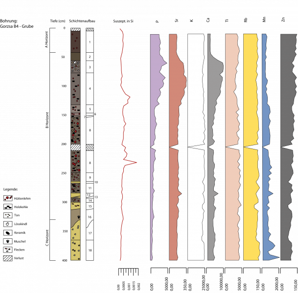
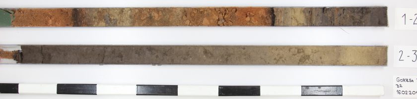
Figure 2 Documentation and analysis of a drill core from Gorzsa (Hungary). After the interpretation of the magnetometer measurements, a specific anomaly was drilled, which is probably the remains of a burnt building. [Attribution: M. Podgorelec; Copyright: RGK]
Much more information can be extracted from the drillings and soil chemical analyses. In 2019, additionally to magnetic measurements, we also carried out boreholes at the Hungarian site Hódmezővásárhely-Gorzsa. This is a Tell settlement of the Neolithic Age, i.e. a settlement that existed about 7000 years ago and which is still recognisable in the landscape today as an elevation or a hill. Over decades and centuries people built on the same spot on top of buildings that had fallen apart, were destroyed and levelled causing the settlements to grow even higher (see for another example of a Tell settlement ELTE-RGK Test-Ausgrabung zur Grabenanlage einer spätneolithischen Tell-Siedlung in Ostungarn). In the magnetic image we were able to identify a number of burnt buildings, one of which was drilled as an example (Fig. 2). The cultural layers of the drill core end at a depth of 2.70 m, with phosphorus levels already decreasing from a depth of 2.10 m. Layers of burnt clay confirm the remains of at least one burnt building. At this point, the phosphorus values match the calcium and potassium values, which further supports the assumption that it is indeed a burnt building. The phosphorus values mostly show elevated values of 3000 to 6000 ppm in the archaeological layers (B-horizon) and testify to the anthropogenic influence. However, the very high values of up to 9000 ppm in the upper range indicate modern influences (A-horizon). Despite a separating layer, the two layers of burnt clay could belong to the same phase of a house where the walls have collapsed. Due to the separating layer, however, it could also be several phases of one or different houses that burned and collapsed at different times. This would not be unusual for a Tell settlement, and other Tell sites in the region have been found to have as many as five superimposed layers of burnt buildings. In the case of Gorzsa, future analyses and field research as well as a comparison with older excavation data will certainly shed light on the matter.
Analyses of soil samples have been carried out at the RGK for many years and the data is available to us in numerous comprehensive tables. By the way, viewing and evaluating these tables is an activity that can easily be done in home office. RefPGM staff are currently working on this data from home and are also looking at ways of improving and expanding sampling strategies and sample preparation, the possibilities for evaluation as well as archiving the data and samples, so that in future further, perhaps even new analyses can be carried out on soil samples from excavations and drillings.
Further information on this topic can be found, for example, in the Excavation Technician Newsletter issue 16/2020:
https://feldarchaeologie.de/wordpress/wp-content/uploads/2020/01/Publ_News_16s.pdf
What else?
We can name a whole range of other examples of archaeologically relevant information which can be obtained from soil samples.
It was a sensation a few years ago when scientists at the Max Planck Institute for Evolutionary Anthropology succeeded in extracting ancient DNA from cave sediments of various mammals. Among them was actually DNA belonging to Neanderthals. In the Denisova Cave in Russia, DNA of Denisova man, who has only been known for a few years, was also found:
https://www.mpg.de/11247830/dna-cave-sediments
https://www.nature.com/news/ancient-human-genomes-plucked-from-cave-dirt-1.21910
Colleagues at the RGK are also pursuing a small pilot project with the MPI in Leipzig.
Two years ago, the Smithsonian Institute titled „How the Remnants of Human Poop Could Help Archaeologists Study Ancient Populations“ (https://www.smithsonianmag.com/science-nature/remnants-human-poop-help-archaeologists-study-ancient-populations-180970337/), referring to an article published in the Journal of Archaeological Science in May 2018 by A. J. White and colleagues. In simple terms, human excrement in soil samples was used to derive changes in population size in Cahokia, Illinois, the largest pre-Columbian settlement in the territory of the USA today. Other archaeological projects have also succeeded in using human or animal faecal remains in soil samples to make statements about the population density of sites.
Microbiological analyses, which can be used, for example, to detect bacteria, fungi and other micro-organisms can sometimes provide information on diseases and certain human activities. Archaeobotany already has a long research tradition, using soil samples to make assumptions on nutrition, landscape and environment as well as climate based on pollen analyses, macro-residue analyses (e.g. preserved seeds and fruits) or so-called phytoliths (microscopic structures of silica which occur in some plant tissues and can be preserved in the soil for a long time). Such studies are also being carried out at the DAI, for example at the Natural Science Department in Berlin (https://www.dainst.org/standort/-/organization-display/ZI9STUj61zKB/18594).
We are closely monitoring the developments in the field of scientific analysis on and with soil samples. It is quite clear, that the potential of soil samples for research into human history should not be underestimated. On the contrary, research in recent years suggests that methods already known will continue to develop and new techniques for extracting scientific information from soil samples will emerge.
It therefore seems all the more important to us to further expand and professionalise our practice of archiving drilling cores and soil samples. For the future, we therefore envisage a magazine in which drilling cores and soil samples can be stored under the best possible conditions in order to make these important archives available for future investigations. We are therefore in active exchange with various scientists at institutes for geoscience and research facilities.
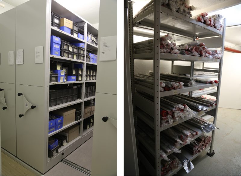
Figure 3 Inconspicuous treasures: The current sample archive at the RGK in Frankfurt. [Attribution: I. Hohle; Copyright: RGK]
The archaeological aspects of soil may only be a small part of its importance and it should be given more attention, especially as a not infinite natural resource. In any case, archaeologists have long since stopped mindlessly digging up the earth and the potential of soil as an archaeological source for human history is becoming increasingly evident.
In this sense:
Happy World Soil Day!