With the aim of continuing the research on intra-African contacts and interaction routes between the 2nd and early 1st millennium BC in the Horn of Africa, further interdisciplinary prospections took place in Djibouti in March/April 2024. The fieldwork was carried out in cooperation between the “Routes of Interaction” project and the Research Centre for Ancient South Arabia and Northeast Africa at Friedrich Schiller University Jena (W. Smidt). Organised jointly by K. Pfeiffer, J. Hardt and H. Riemer of the German-Djiboutian team, an archaeological-geographical survey was carried out along the coast and inland of the Sultanate of Tadjourah. The work was based on the results of the previous year’s excursions, the analysis of satellite images, information from employees of L’Institut de recherches archéologiques et historiques (IRAH) and the local population.
The questions anchored in the project about the land of Punt mentioned in Egyptian sources and its possible localisation brought the Sultanate of Tadjourah to the forefront of the research trip, where 2023 occurrences of incense trees were documented.
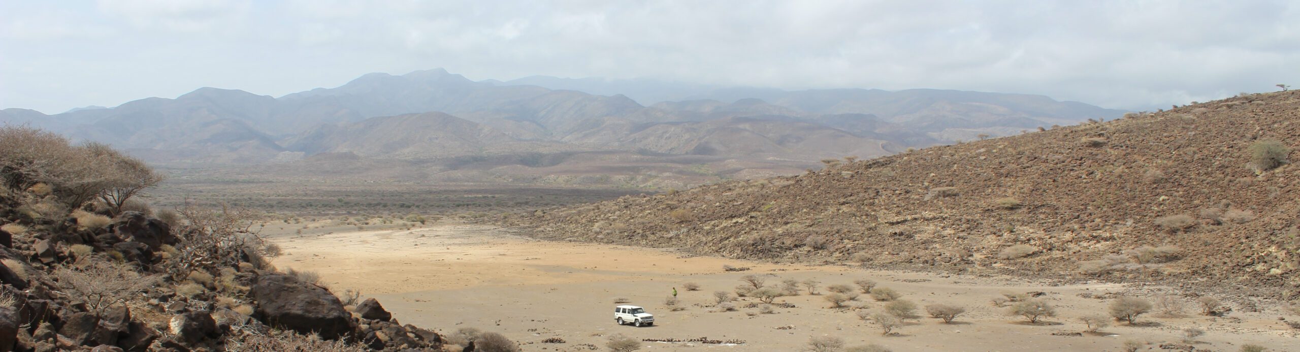
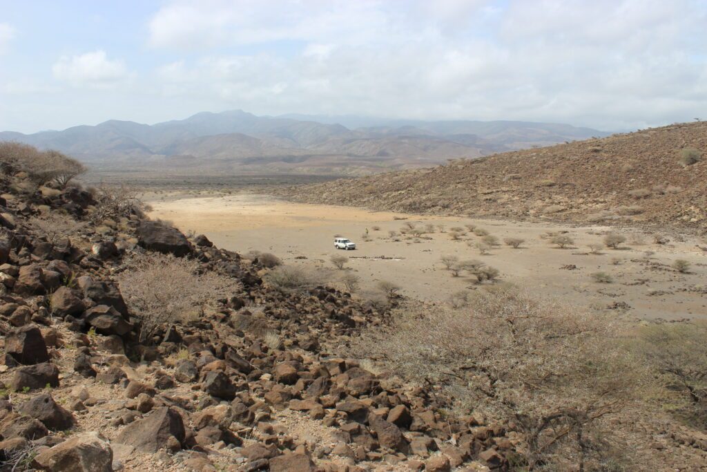
Thanks to the interdisciplinary nature of the project, it was possible to gain a wide range of insights into the cultural landscape of the Sultanate of Tadjourah (Figure 1). The region under investigation consists of tectonic, geological and geomorphological landscape zones, some of which are clearly divergent and which differ not only in terms of climate, but also in terms of their different traditions of use and cultural landscapes. In addition to numerous settlement structures, the recorded path networks and overland trails indicate the social and cultural importance of the region. The number and spatial distribution of burial mounds from different periods consolidate these observations and suggest long lines of tradition.
Fig 1: The landscape near Ghoubet, in the background the mountains of the hinterland (Attribution & Copyright: K. Pfeiffer)
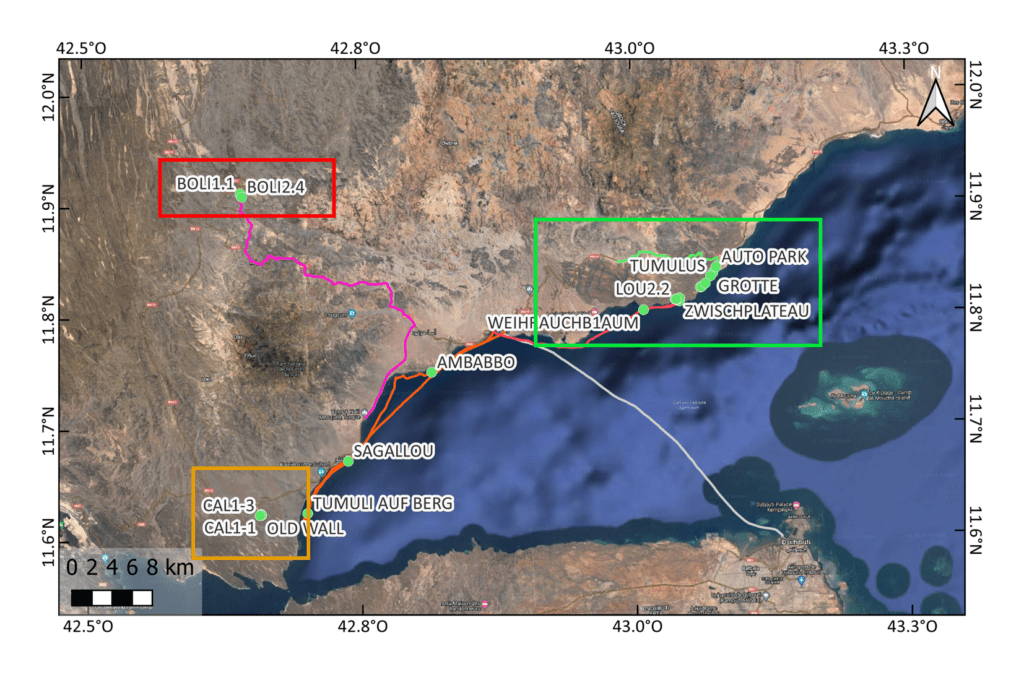
Fig. 2: Overview map of the individual working areas in the Sultanate of Tadjourah: Randa/Boli (BOLI), volcanic crater near Ghoubet (CAL) and Loubatanlé (LOU) (Attribution & Copyright: J. Hardt based on GoogleEarth)
The survey focused on three different survey areas, each of which differed from one another in terms of topographical features. This allows us to model routes and explore the interaction between different regions and sites within very different environments, which can then be transferred to other regions. The sites of Loubatanlé, Randa/Boli and a volcanic crater near Ghoubet were selected for prospection and microsondages (Figure 2). These sites are not only rich in archaeological remains, but also have different geostrategic locations.
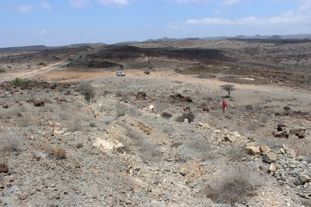
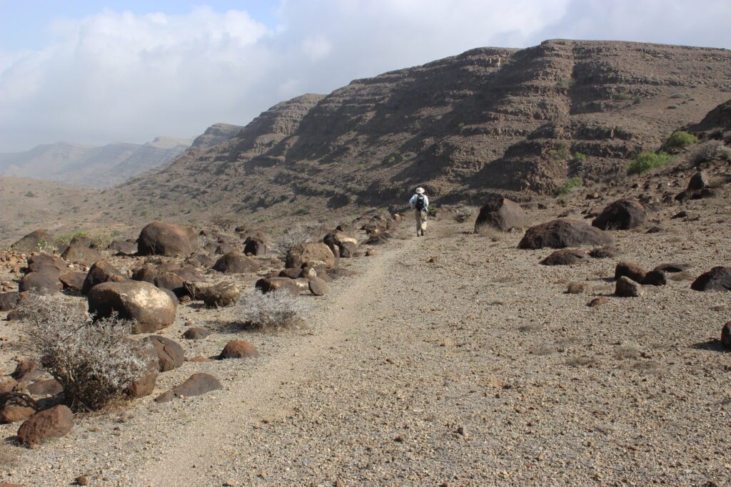
The Randa/Boli site is located near a mountain pass (approx. 900 metres above sea level). Numerous burial mounds, settlement structures and an extensive system of paths form a kind of crossroads of overland trails and landscape zones (Figure 3). A north-south axis forms the transition from the coastal region to the extensive basalt landscapes of the hinterland, while the east-west axis connects deeply incised valley systems and tectonic trenches with mountain ranges and spurs. Route sections connecting the highlands with the coastal lowlands or running along the highlands can be modelled from Randa/Boli. In addition to route networks that run within the archaeological area, long-distance routes tangential to the area were also recorded (Figure 4). A large number of burial mounds indicate repeated visits to the area and the socio-cultural significance of the site. On the basis of comparative findings, the burial mounds can be dated to a period between the 3rd mill. BC and the 1st millenium CE (Figure 5). In addition to flakes and tool fragments made of obsidian, pottery sherds were documented. One sherd of a characteristic type of pottery was found, which was previously only known from the Gobaad plain in south-west Djibouti and can be dated to the 2nd millennium BC. More detailed investigations are currently underway. Sediment sampling was carried out using microsondages, and charcoal inclusions from these sediments are currently being analysed for 14C dating in the Poznan Radiocarbon Laboratory. Geochemical analyses of the sediments are also being carried out.
Fig 3: View of the Randa/Boli ridge with the archaeological site. An extensive network of paths connects the area regionally and beyond (Attribution & Copyright: K. Pfeiffer).
Fig. 4: Randa/Boli: Routes lead along the transitions of the landscape forms and could have served as long-distance routes (Attribution & Copyright: J. Hardt)
Fig. 5: Tumulus in Randa/Boli, probably belonging to the oldest examples of tumuli at the site (possibly 3rd millennium BC) (Attribution & Copyright: K. Pfeiffer)
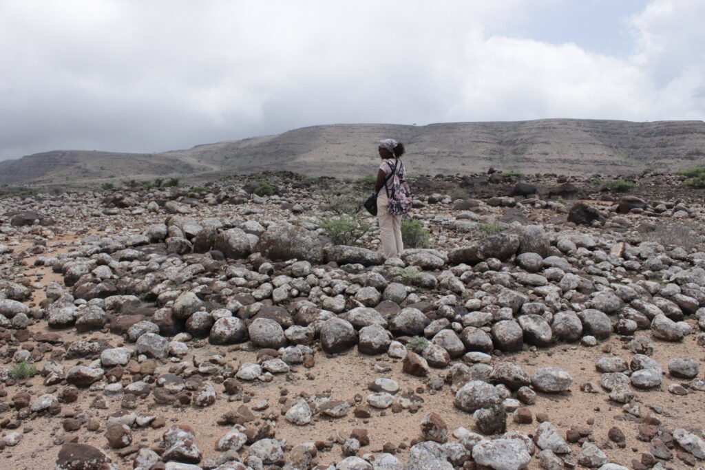
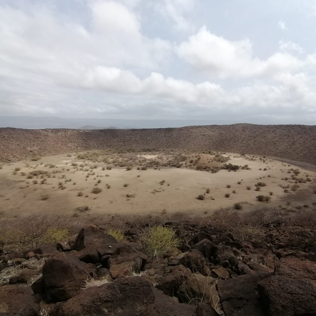
The volcanic crater near Ghoubet, which is located about 40 km west of Tadjourah city in the southern part of the Wadi Asa Foo, is unique due to its location and shape. The circular crater with a diameter of around 300 m is characterised by a light-coloured, fine-grained substrate with water-accumulating properties (Figure 6). A large lake had formed here after a rain event. The vegetation inside the crater also shows better water availability than the surrounding landscape. Numerous stone structures of different sizes can be recognised on the rim of the inner crater (Figure 7), on the crater slope, on the outer crater circle and on the adjacent terraces. The closed crater ring provides a protected area. It could possibly have been used for watering herd animals, as a caravan station or, in view of the stone structures, as a religious and cultural centre for the local population. An extensive network of paths and tracks not only connects the stone structures with each other, but also links the crater to other regions. The Wadi Assa Foo, in which the crater is located, is the only accessible north-south connection in the west of the Gulf of Tadjourah. The wadi leads from the coast through inhospitable volcanic landscape into the hinterland, which is suitable for pastoralism, and offers a northern route that could also have been used by caravans. The finds of obsidian and pottery are currently being analysed, as are the charcoal samples obtained from microsondages.
Fig. 6: View into the volcanic crater near Ghoubet (Attribution & Copyright: K. Pfeiffer)
Fig. 7: Stone structures of different shapes and sizes at the rim of the inner crater (Attribution & Copyright: K. Pfeiffer).
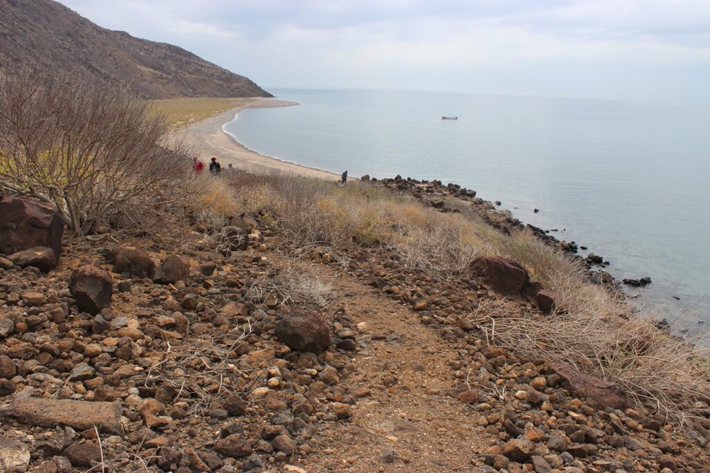
The importance of Loubatanlé became very clear during the exploratory trip in 2023. The incense trees, which make the place particularly attractive for the “Routes of Interaction” project, grow on the edge of the plateau and on the cliff. At least two paths connect the high plateau with the coast. Whether these paths could be linked to ancient incense transport was the subject of this year’s investigations in the field. At the foot of the Loubatanlé cliff, the coast was surveyed over a total length of 2 kilometres. On the one hand, the aim was to identify potential landing sites for the possible ancient shipment of goods (e.g. incense) on the shallow sandy beaches (Figure 8). On the other hand, paths leading to the high plateau with the incense vegetation were prospected. Two significant paths were studied to determine whether the subsoil and gradient would be passable for pack animals, which can be confirmed on the basis of empirical comparative studies (Figure 9).
Fig. 8: A small cove with an incense tree near Loubatanlé, where it was possible to land by boat in rough seas (Attribution & Copyright: K. Pfeiffer)
Fig. 9: Prospection of a path from the coast to the 300 m high cliff with the incense trees in Loubatanlé (Attribution & Copyright: K. Pfeiffer)
The investigation of connecting routes between potential landing sites and the 300-metre-high incense cliff was one of the key topics for the 2024 season. As the coastal prospection was carried out both on foot and by boat, it was possible to gain important insights into the significance of the tide and wind conditions in the coastal area. Parts of the coast have offshore coral reefs that make it impossible to land during low tide; even small, shallow boats cannot land. Another factor is the winds, which can be very strong in this area as the Gulf of Tadjourah widens towards the east. Due to the strong winds, a high swell can form, which then breaks against the coral reefs in the form of strong waves – making it impossible for a small boat to land. Although people can reach the shore by wading or swimming, and cargo can also be brought ashore in this way – what cannot reach land in these conditions are pack animals. These observations allow conclusions to be drawn about the seasons, which have an influence on (modern and ancient) ship transport.
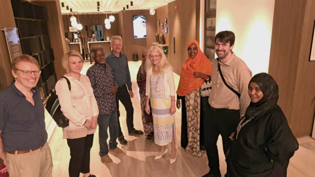
The cultural-political component of the research trip to Djibouti consisted of a workshop on methods in field research organised jointly with the IRAH, a meeting with the Sultan of Tadjourah and a meeting with the German Ambassador to Djibouti, Dr Heike Fuller (Figure 10).
Fig. 10: Joint iftar with the German Ambassador to Djibouti, H.E. Dr Heike Fuller, and the staff of the IRAH (Attribution & Copyright: M.Y. Gadʿay)
This website uses cookies to improve your experience while you navigate through the website. Out of these, the cookies that are categorized as necessary are stored on your browser as they are essential for the working of basic functionalities of the website. We also use third-party cookies that help us analyze and understand how you use this website. These cookies will be stored in your browser only with your consent. You also have the option to opt-out of these cookies. But opting out of some of these cookies may affect your browsing experience.
Necessary cookies are absolutely essential for the website to function properly. This category only includes cookies that ensures basic functionalities and security features of the website. These cookies do not store any personal information.
Any cookies that may not be particularly necessary for the website to function and is used specifically to collect user personal data via analytics, ads, other embedded contents are termed as non-necessary cookies. It is mandatory to procure user consent prior to running these cookies on your website.
![[Attribution: unknown; Copyright: not defined]](https://www.dainst.blog/entangled-africa/wp-content/uploads/sites/11/elementor/thumbs/Fig8_blog-P07-scaled-qps7s17an179malxqw97hm9aa3iturki9kqqyj5g4q.jpg "Fig8_blog P07")